Show house numbers only on zoom 18 and 19 #1935
Labels
No labels
Accessibility
Accessibility
Address
Address
Android
Android
Android Auto
Android Auto
Android Automotive (AAOS)
Android Automotive (AAOS)
API
API
AppGallery
AppGallery
AppStore
AppStore
Battery and Performance
Battery and Performance
Blocker
Blocker
Bookmarks and Tracks
Bookmarks and Tracks
Borders
Borders
Bug
Bug
Build
Build
CarPlay
CarPlay
Classificator
Classificator
Community
Community
Core
Core
CrashReports
CrashReports
Cycling
Cycling
Desktop
Desktop
DevEx
DevEx
DevOps
DevOps
dev_sandbox
dev_sandbox
Directions
Directions
Documentation
Documentation
Downloader
Downloader
Drape
Drape
Driving
Driving
Duplicate
Duplicate
Editor
Editor
Elevation
Elevation
Enhancement
Enhancement
Epic
Epic
External Map Datasets
External Map Datasets
F-Droid
F-Droid
Fonts
Fonts
Frequently User Reported
Frequently User Reported
Fund
Fund
Generator
Generator
Good first issue
Good first issue
Google Play
Google Play
GPS
GPS
GSoC
GSoC
iCloud
iCloud
Icons
Icons
iOS
iOS
Legal
Legal
Linux Desktop
Linux Desktop
Linux packaging
Linux packaging
Linux Phone
Linux Phone
Mac OS
Mac OS
Map Data
Map Data
Metro
Metro
Navigation
Navigation
Need Feedback
Need Feedback
Night Mode
Night Mode
NLnet 2024-06-281
NLnet 2024-06-281
No Feature Parity
No Feature Parity
Opening Hours
Opening Hours
Outdoors
Outdoors
POI Info
POI Info
Privacy
Privacy
Public Transport
Public Transport
Raw Idea
Raw Idea
Refactoring
Refactoring
Regional
Regional
Regression
Regression
Releases
Releases
RoboTest
RoboTest
Route Planning
Route Planning
Routing
Routing
Ruler
Ruler
Search
Search
Security
Security
Styles
Styles
Tests
Tests
Track Recording
Track Recording
Translations
Translations
TTS
TTS
UI
UI
UX
UX
Walk Navigation
Walk Navigation
Watches
Watches
Web
Web
Wikipedia
Wikipedia
Windows
Windows
Won't fix
Won't fix
World Map
World Map
No milestone
No project
No assignees
3 participants
No due date set.
Dependencies
No dependencies set.
Reference: organicmaps/organicmaps-tmp#1935
Loading…
Add table
Reference in a new issue
No description provided.
Delete branch "%!s()"
Deleting a branch is permanent. Although the deleted branch may continue to exist for a short time before it actually gets removed, it CANNOT be undone in most cases. Continue?
When looking at the map in a city, house numbers (addresses) really clutter the view. Some start appearing on a low zoom level (16), and the rest by further zooming in.
Showing just a few house numbers is completely useless: unless the exact house number you are looking for appears, it is just cluttering your view with unnecessary information. Then when the majority of house numbers appear, the zoom level is still too low (17) because you are usually seeing a whole neighborhood.
What would be more useful would be to show house numbers only when really zoomed in on a street (zoom level 18 and 19 only), because you only need to see house numbers when you found the associated street.
Same thinking can be applied to navigation mode.
Might help in solving #1656
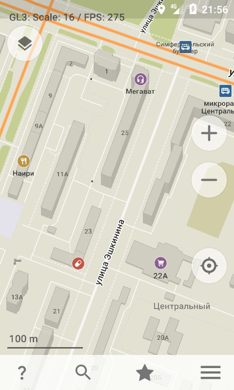
It depends on average buildings sizes in displayed area. E.g. with large multi-apartment buildings in ex-USSR countries house numbers are looking good and are useful at zoom level 16:
I don't see a way we can fix it for all cases unless we have a dynamic display based on density of features in a viewport.
A display based on density would probably be the best, but maybe not the easiest to implement. After more testing, I found showing house numbers only on levels 18 and 19 would not be enough to reduce clutter.
As a temporary fix, a setting could be added to show/hide house numbers globally. I personally nearly never used the house numbers from the map and always relied on the search. Sometimes when there are a lot of POIs, even showing the numbers on a low zoom level is cluttering the view.
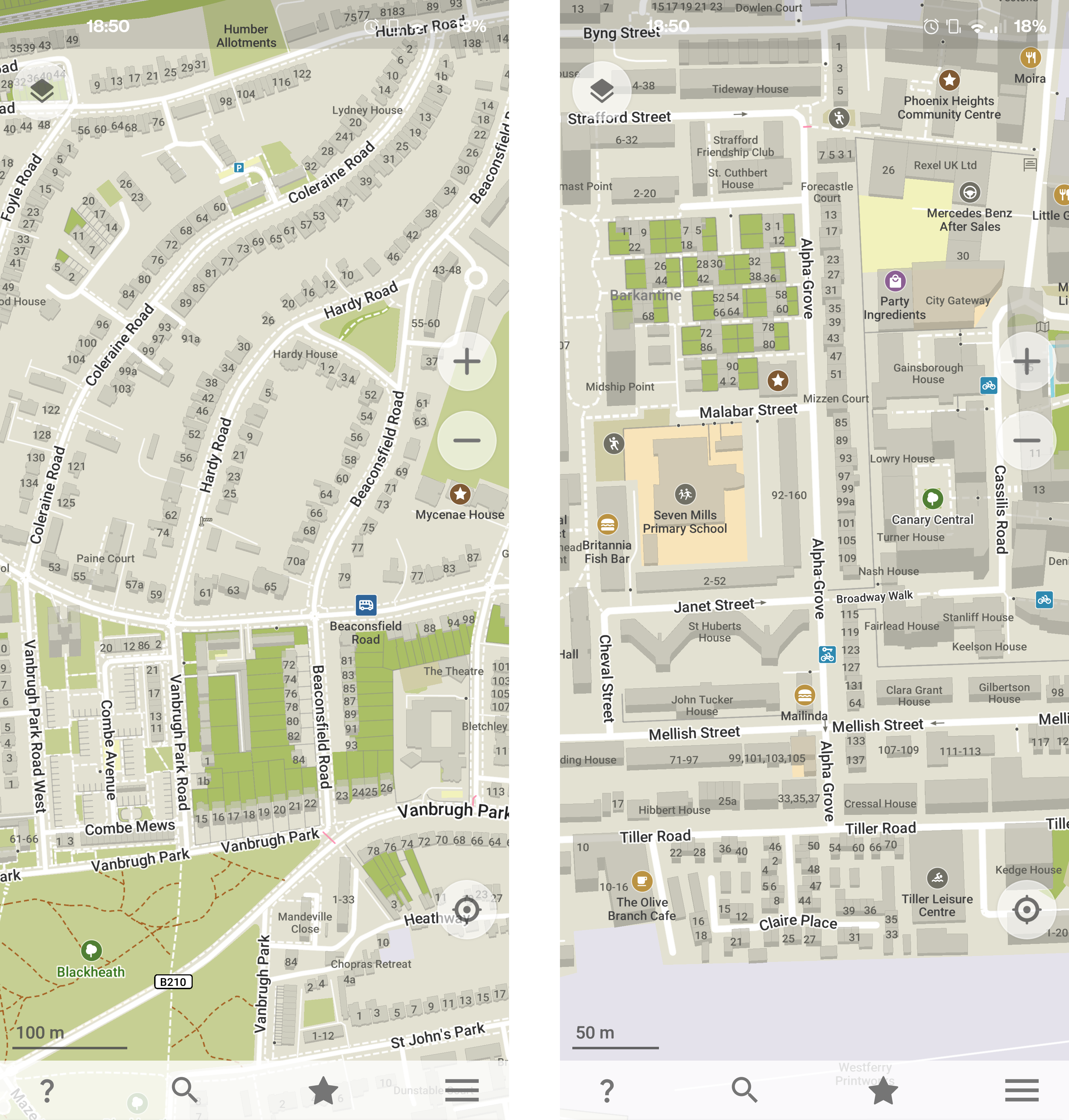
As an example, here are some screenshots of the center of Toulouse in France. Even on zoom level 19 house numbers are distracting, and you often end up clicking on a house number instead of a POI. While navigating, house numbers are completely useless because you often enter the number you want to go to as the destination.
Please don't forget that by drawing house numbers we motivate people to add missing numbers via OM's editor. This is also an important feature.
But addresses as shown in the map here are made from nodes tagged with
addr:housenumber(see the osm wiki) and users cannot add those with OM's editor. This is how addresses are mapped in a lot of places in France, don't know about the rest of the world.But in any case, when users are using the navigation they do not have the time to add missing addresses so they do not need to see those.
You can edit any building's address (street, house number, postal code) and height directly from OM.
I agree that house numbers during active navigation should be hidden in favor of street names and other important POIs. That issue should be already somewhere on Github. This can be solved by editing our existing "vehicle" style.
Checing some areas nearby, housenumber displaying seems to be good right now - anything remains to be done in this issue?
While driving, it is useful to see nearby/neighborhood numbers, it helps to find a house faster.
Displaying house numbers helps to edit and add missing ones (and helps to select a building).
Also so far only a few users out of millions (including mapsme) complained about them.
A smarter approach would be a dynamic style to avoid cluttering if there are many nearby POIs and do not display a few numbers if others are not displayed.
Perhaps rendering of house numbers can be disabled on lower zoom levels for everything except
building=apartments(and similar)In my area, basically all houses are either
building=houseorsemidetatched_house& the house numbers result in a lot of visual clutter.coords for 1: 51.48005/0.01384
coords for 2: 51.49808/-0.02445
This will not work for every country. As I said for France house numbers are separate features from the building:
Thus those nodes will not have the tags
building=house.Ah fair point, biodranik suggested using
FeatureID Framework::FindBuildingAtPoint(m2::PointD const & mercator) constfor a similar issue (link), maybe getting the building type from that would solve it?That would not solve the issue as those addresses could be out of the building if it is far from the road:

.
ohh, that's strange. In that case yeah only calculating density would fix it. Are you sure that's a standard/accepted mapping practice though?
Here are the mapping practices from the French OSM wiki: https://wiki.openstreetmap.org/wiki/FR:Adresses#Comment_cartographier_les_adresses
It does not mention out of building addresses but I have observed this quite often. From what I could find, some cities import addresses from official parcel documents called the "Cadastre". In those documents house numbers are written on the edge of the parcel, which may not be the building itself. When enabling the Cadastre layer on the Vespucci app, you can see the house number nodes are at the same place as in the Cadastre:
But then again, I could not find a rule about this, and it really depends on the local mapping practices.
You're doing really strange things there in France. But you have great food that compensates for everything :)
Regarding the issue, I would ask a question to the French OSM community. I assume that marking buildings with numbers is a better idea than using numbers outside. And it's a question of time when volunteers fix it. Maybe we can make it easier to fix directly from OM :)
@arnaudvergnet which part of France are you from?
I observed this in several cities such as Toulouse, Paris, Lyon, Bordeaux. There may be others but these are some of the bigger cities so it impacts a lot of people.
We recently had similar discussions in Latvia, as our corresponding state agency published addresses as open data.
Where there is a corresponding building in OSM data, address info is assigned to that - but many, many addressed will get a node only.
Overall, personally I'm much more happy to see more addresses than less. It helps both with navigation and mapping.
What about calculating in the generator & storing the area of the polygon? That wouldn't have any performance impact for the app runtime. The addresses as nodes complicate it, but it could be a good solution for a lot of cases.